By participating in these activities, these children
learnt about stormwater pollution, how it affects
their local creek and what they can do to keep their
creek, Middle Harbour and the Lane Cove River clean.
Enhance Harbour and River Foreshores
Project aims involve the improvement of drainage
lines and stormwater outlets, including channel
armouring, revegetation and rubbish removal. Some
of the activities achieved were the enhancement
of 800m of the Lane Cove River foreshore, the complete
restoration of Artarmon Reserve Creek and the repair
and stabilisation of damaged sections of sea walls
in Castle Cove, along Castlecrag’s northern
escarpment and in Northbridge, with sandstone boulders.
Water Monitoring
Program
Council has recently commenced a Water Monitoring
Program designed to assess the water quality of local
creeks and streams. Water samples are collected
monthly from major creeks and streams within the area
and are analysed for a range of physical, biological
and bacteriological parameters. The aim of this program
is to provide long term data which will enable Council
to identify major sources of pollution within our
waterways and will allow Council to implement appropriate
management techniques to improve water quality.
Some of the creeks
projects are:
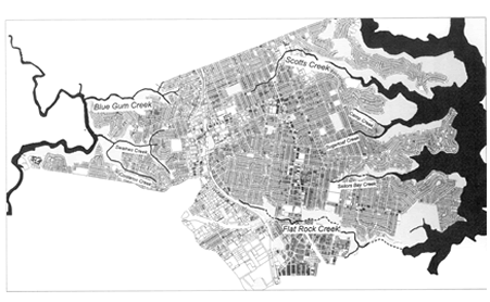
Main Creeks within Willoughby
Council area
Scotts Creek
Scotts Creek is one of the most degraded watercourses
within the Willoughby Council area. It runs from the
Chatswood CBD and industrial area to the beautiful
Sugarloaf Bay. The high number of point sources entering
the bushland and the physical characteristics of Scotts
Creek means that the whole of the creek is receiving
polluted urban runoff.
Currently Willoughby Council is working on the regeneration
of bushland adjacent to Scotts Creek. The works include
removal and control of noxious weeds, revegetation
and follow-up monitoring.
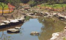 At Muston Park, the concrete channel that once was
part of Scotts Creek was turned into a natural watercourse.
The channel was relined with sandstone and weirs were
created in order to slow down the water allowing sediment
to settle out. Extensive planting has been also
carried out on the banks and in the water.
At Muston Park, the concrete channel that once was
part of Scotts Creek was turned into a natural watercourse.
The channel was relined with sandstone and weirs were
created in order to slow down the water allowing sediment
to settle out. Extensive planting has been also
carried out on the banks and in the water.
Further work to clean up the creek including rubbish
traps and education of shoppers is under way. The
project under Stormwater Trust funding ‘Provision
of Litter Control System for the Chatswood CBD and
residential areas in the Scotts Creek Catchment’
intended to capture gross pollutants flowing from
the busy Chatswood CBD and residential areas. It is
done by placing rubbish traps in several strategically
chosen pits in the CBD and one large trap in the Scotts
Creek stormwater channel, which drains the main part
of the catchment. Signage and information about the
trap location and effectiveness are ways of reinforcing
the education message at the source. There will be
plaques placed on the footpath next to pits with traps
in them alerting shoppers to their presence and the
amount of rubbish being captured.
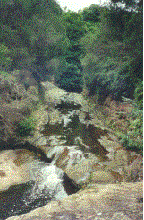
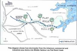
Flat Rock Creek
Flat Rock Gully was once a natural valley with waterfalls,
and a tidal estuary. From the mid 1930s until as recently
as 1985 tipping operations filled the upper area,
resulting in major environmental impacts, such as
loss of flora and fauna, contamination of the creek
line and stormwater runoff carrying pollutants to
the catchment.
Currently the area includes historical
sites such as an incinerator built in 1934, a well
preserved example of Walter Burley Griffin’s
architecture; the suspension bridge constructed in
1892 and rebuilt in the 1930’s; and Fatty Dawson’s
ruins, remains of a sandstone house and piggery from
the 1870’s. The area is also contains aboriginal
heritage sites.
 Flat Rock Gully and Bicentennial reserve provide a
large integrated open space corridor leading to Long
Bay with extensive remnant bushland close to urban
areas. The bush provides habitat for some rare plant
and animal communities and forms a valuable natural
resource for environmental education.
Flat Rock Gully and Bicentennial reserve provide a
large integrated open space corridor leading to Long
Bay with extensive remnant bushland close to urban
areas. The bush provides habitat for some rare plant
and animal communities and forms a valuable natural
resource for environmental education.
Despite human impacts the creek system still provides
habitat for a number of aquatic species including
mullet, common jolly tails, striped gudgeons, long-finned
eels, long-necked turtles, frogs and water birds.
Many birds can be seen, e.g. eastern yellow robin,
grey fantail, eastern whipbird, tawny frogmouth, golden
whistler, superb blue wren, spotted pardalote and
red-browed firetail. Spherical nests in trees (dreys)
indicate the presence of ringtail possums. Eastern
water dragons may be seen sunning themselves on rocks.
Being an important natural and historical area,
Willoughby Council, together with community groups
as the Flat Rock Landcare Group, have been developing
a series of revegetation and bush regeneration projects,
along with industry awareness and schools programs.
Revegetation and Bush
regeneration – To re establish native
vegetation, improve creek health and wildlife habitat,
qualified bush regeneration contractors and council
staff along with some volunteers are planting native
species and controlling noxious weeds. This
work is done in accordance with the urban Bushland
Plan of Management and the Flat Rock Gully and Bicentennial
Reserve Plan of Management. Establishment of bush
friendly backyards in residences fringing on Flat
Rock Gully is also encouraged.
Industry awareness
– there is an education program liaising with
industry on pollution and erosion control issues.
One of the initiatives is the distribution of information
on current stormwater management practices on constructions
sites.
 School programs - aimed to develop catchment awareness
among school children by involving them in activities
such as: interpretive magic bush walks, wildlife
watch, water testing, drain-stencilling, regeneration,
composting and recycling initiatives. The schools
participating are: Northbridge Public School, St.
Philip Neri Primary School and Willoughby Girls
High School.
School programs - aimed to develop catchment awareness
among school children by involving them in activities
such as: interpretive magic bush walks, wildlife
watch, water testing, drain-stencilling, regeneration,
composting and recycling initiatives. The schools
participating are: Northbridge Public School, St.
Philip Neri Primary School and Willoughby Girls
High School.
To guarantee easy public access to the areas to
be revegetated or restored, access tracks were built.
Despite its past degradation, presently Flat Rock
Gully and Bicentennial reserve are examples of restoration
in progress.
Blue Gum Creek
Blue Gum Creek is within the Lane Cove River catchment
and is surrounded by areas of important remnant vegetation.
The health of the creek suffers from the pollutants
coming from the Pacific Highway, houses and commercial
premises in the catchment.
Willoughby Council has developed a series of projects
to reduce these impacts, such as: sediment traps,
trash racks and creek bank revegetation. An interpretative
program to educate and inform the local community
about the projects and how they can actively help
to protect and restore the creek has commenced.
Instituto Ambiental
Ratones (IAR)
Instituto Ambiental Ratones is a non-government,
non-profit organisation, working on environmental
education, preservation and restoration on Santa Catarina
Island. Some of the IAR projects include:
Environmental
Education
IAR has been involved in a series of environmental
education and interpretation projects, such as: establishing
signed tracks and developing a visitation plan for
Rio Vermelho forest park. IAR is also responsible
for the management of Olandi-Jurerê
Reserve. a joint initiative between private
and non-government organisations. The area is situated
in the buffer zone of the Ecological Reserve of Carijós
and has one of the last remnants of restinga forest
on Santa Catarina Island. An interpretive track was
built in the area and a program for school kids is
being developed in the reserve.
Mar
Limpo Project
This project aims to enhance awareness of ocean pollution,
by involving the local community, tourists and school
kids in environment related activities, such as water
monitoring and competitions.
Creek Restoration
One of IAR projects is to restore
an area of 30 hectares surrounding the Pau do Barco
River, which is part of the Saco Grande mangrove
catchment area. The environmental degradation of
the riverbanks and water pollution are impacting
on the Ecological
Reserve of Carijós.
The project will be developed over a period of 3
years and revegetation of the riverbanks and environmental
education are proposed.